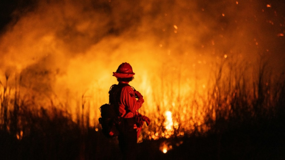
Slew of satellite projects aims to head off future wildfires / Photo: © AFP/File
 US troops in Syria killed in alleged IS ambush

 M23 marches on in east DR Congo as US vows action against Rwanda

 Terrific Terrier returns Leverkusen to fourth

 US troops in Syria killed in IS ambush attack

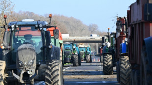 'Stop the slaughter': French farmers block roads over cow disease cull

 Maresca hails Palmer as Chelsea return to winning ways against Everton

 Belarus frees protest leader Kolesnikova, Nobel winner Bialiatski

 Palmer strikes as Chelsea return to winning ways against Everton

 Salah back in action for Liverpool after outburst

 Meillard leads 'perfect' Swiss sweep in Val d'Isere giant slalom

 Meillard leads Swiss sweep in Val d'Isere giant slalom
 Cambodia shuts Thailand border crossings over deadly fighting

 Vonn second behind Aicher in World Cup downhill at St Moritz

 Thailand says 4 soldiers killed in Cambodia conflict, denies Trump truce claim
 Women sommeliers are cracking male-dominated wine world open

 Myanmar junta denies killing civilians in hospital strike

 Thailand continues Cambodia strikes despite Trump truce calls
 North Korea acknowledges its troops cleared mines for Russia

 Cambodia says Thailand still bombing hours after Trump truce call

 Leinster stutter before beating Leicester in Champions Cup

 Crypto firm Tether bids for Juventus, is quickly rebuffed

 US Treasury lifts sanctions on Brazil Supreme Court justice

 Wembanyama expected to return for Spurs in NBA Cup clash with Thunder

 UK's king shares 'good news' that cancer treatment will be reduced in 2026

 Iran detains Nobel-prize winner in 'brutal' arrest

As Los Angeles firefighters battle remaining hotspots more than a week into deadly blazes, scientists and engineers hope growing availability of satellite data will help in the future.
Tech-focused groups are launching new orbiters as space launches get cheaper, while machine learning techniques will sift the torrent of information, fitting it into a wider picture of fire risk in a changing environment.
Satellites "can detect from space areas that are dry and prone to wildfire outbreaks.... actively flaming and smouldering fires, as well as burnt areas and smoke and trace gas emissions. We can learn from all these types of elements," said Clement Albergel, head of actionable climate information at the European Space Agency.
Different satellites have different roles depending on their orbit and sensor payload.
Low Earth orbit (LEO) is generally less than 1,000 kilometres (620 miles) above the surface -- compared with up to 14 km for an airliner.
Satellites here offer high-resolution ground images, but see any given point only briefly as they sweep around the planet.
Geostationary satellites orbit at around 36,000 km, remaining over the same area on the Earth's surface -- allowing for continuous observation but usually at much lower resolution.
As climate change brings growing numbers of wildfires encroaching on human-inhabited areas, that resolution can be crucial.
In Los Angeles, "there are satellite observations, but it's very hard to determine -- is it my house that's on fire? Where exactly is this?," said WKID Solutions' Natasha Stavros, a wildfire expert who has also worked at NASA.
"Some people stay because they don't really understand... that's where this idea (that) we need more observations available comes from."
- 'More fire than we know' -
Brian Collins, director of Colorado-based nonprofit Earth Fire Alliance, plans a new low-orbit satellite "constellation" to complement existing resources.
It will sport a sensor with a resolution of five metres (16 feet), much finer than ESA's current Sentinel-2 satellites that can see objects only 10 metres wide.
This means "we're going to learn very quickly that there is more fire on the Earth than we know about today, we're going to find very small fires," Collins predicted.
EFA aims to launch four satellites by the end of 2026, the first in just a few weeks, at a total cost of $53 million.
That figure is a "drop in the bucket" against the property damage and lives lost to wildfires, said Genevieve Biggs of the Gordon and Betty Moore Foundation, which has financially supported EFA's satellite project.
It would take the whole planned swarm of 55, costing a total $400 million, to reach Collins' aim of imaging every point on Earth at least once every 20 minutes.
Dozens of satellites in orbit could "both detect and track fires... at a cadence that allows decisions to be made on the ground," Collins said.
Less grandiose efforts include Germany-based OroraTech, which on Tuesday launched the first of at least 14 shoebox-sized FOREST-3 "nanosatellites".
The system will "deliver ultra-fast wildfire alerts and high-quality thermal data," chief executive Martin Langer said in a statement.
The Moore foundation is also backing a geostationary satellite project dubbed FUEGO.
- 'Last mile' -
Additional data from all these new satellites would be "fantastic", ESA's Albergel said, but the large volume of information can prove problematic.
ESA's Sentinel-2 alone sends down one terabyte of data -- the storage capacity of a modern high-end laptop -- every single day.
Finding fire signs in such reams of data "is an excellent machine learning, artificial intelligence problem... the 'needle in the haystack'," Collins said.
The data could ultimately help both predict new fire outbreaks and their progression, he added.
Looking ahead, Stavros said there was no "silver bullet" technology for wildfires.
"It's all of them working together" that will help emergency responders and slash risk from fire, Stavros said.
Beyond high-tech detection and tracking, the Moore Foundation's wildfire programme also focuses on making communities more resilient and managing fire-prone ecosystems -- which can include "increasing ecologically beneficial fire while decreasing detrimental fire", Briggs said.
M.Furrer--BTB