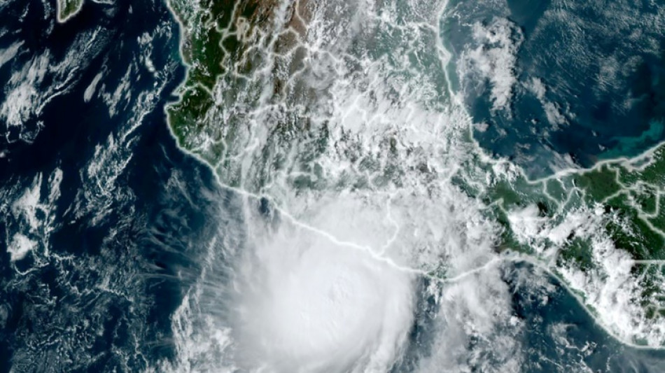
Why did Hurricane Otis 'explosively' intensify off Mexico? / Photo: © NOAA/AFP
 More records set to fall as deadly Europe heatwave drags on

 England, Ghana eye last 32 as Portugal look for lift-off

 Sri Lanka troops to battle deadly dengue mosquitoes as cases rise

 Diaspora World Cup champions diversity over division

 Australia withholds Pacific climate fund reports over risk of diplomatic 'damage'

 Indian startup head appointed as new WhatsApp boss

 Antetokounmpo joining Miami Heat in blockbuster: reports

 'Let's be realistic': Haaland cools Norway's World Cup expectations

 Lightning, downpour, a two-hour delay: bad weather hits the World Cup

 Two-goal Haaland fires Norway into World Cup last 32

 Last one the best one? How Messi keeps doing it at World Cup

 Savea 'embraces challenge' of leading All Blacks towards World Cup

 Savea 'embraces challlenge' of leading All Blacks towards World Cup

 Mbappe scores twice as France beat Iraq at World Cup after two-hour storm delay

 France-Iraq World Cup game restarts after two-hour storm delay

 World Cup exploits of Maradona and Messi have Argentina fans in raptures

 England 'can beat any opponent' at World Cup, says Rice

 Alvarez says 'best for everyone' if he leaves Atletico

 Romanian parliament rejects liberal PM-designate

 Maduro ouster put Venezuela on 'the right path': interim leader

 Shooting in Montreal, Canada leaves three dead including suspect

 Balogun chases 'inevitable' Messi in wild Golden Boot race

 Belgium's Doku becomes father after World Cup controversy

 Magic Messi makes World Cup history to send Argentina into last 32

 Ghana coach Queiroz says playing England 'easiest' World Cup game

Hurricane Otis caused at least 27 deaths and major damage as it battered Mexico's beachside city of Acapulco as a scale-topping category 5 storm, according to officials.
The speed with which Otis rapidly intensified took the government and weather forecasters by surprise, leaving little time to issue warnings and prepare for its arrival.
Why was Otis so devastating?
"Otis's intensification was very exceptional. It was nearly record-breaking in some ways," said Michael Brennan, director of the Miami-based National Hurricane Center (NHC).
Within hours Otis strengthened from a tropical storm to the most powerful category of the five-step Saffir-Simpson scale before hitting land early Wednesday.
Otis "explosively intensified" with peak wind speeds increasing by 115 miles per hour over a 24-hour period, according to the NHC, which issues storm warnings and forecasts.
Otis was packing maximum sustained winds of 165 miles (265 kilometers) per hour when it hit the coast, the NHC said.
The World Meteorological Organization described the hurricane as "one of the most rapidly intensifying tropical cyclones on record," only exceeded in modern times by Hurricane Patricia in 2015.
Why did Otis intensify so quickly?
"Unfortunately Otis was able to take advantage of very favorable conditions" including warm deep ocean water and a conducive atmospheric environment, Brennan said.
"The storm was able to develop an inner core and a structure that allowed it to take advantage of those favorable conditions and environment in the ocean and the atmosphere to rapidly intensify," he said.
While hurricanes hit Mexico every year on both its Pacific and Atlantic coasts, usually between May and November, few make landfall as a Category 5.
"There are no hurricanes on record even close to this intensity for this part of Mexico," the NHC had said as Otis approached the Mexican coast, warning that a "nightmare scenario" was unfolding.
Is climate change to blame?
The water temperatures off the Mexican coast that Otis encountered were 30 to 31 degrees Celsius (86-88 degrees Fahrenheit), Brennan said.
"That may be a little bit warmer than usually but not tremendously so. That area is usually quite warm and has quite deep warm ocean water this time of year," he added.
"So it's hard to necessarily attribute that particular aspect of this to climate change or global warming. We'll have to look back and do some studies," Brennan said.
Will global warming bring more devastating storms like Otis?
Brennan said that "the science on that is not terribly well resolved at this point."
"There are some studies that suggest that rapid intensification is becoming more common in a warming climate," he said.
"We are very confident that the impacts of hurricanes from heavy rainfall, flooding and storm surge are worsening in a warming climate and will continue to worsen as the climate warms," he added.
That was due to rising sea levels leading to more dangerous storm surges and a warmer atmosphere holding more moisture, resulting in heavier rainfall, Brennan said.
The UN's Intergovernmental Panel on Climate Change said in 2021 that the proportion of particularly intense cyclones (categories 4 and 5) should increase by 10 percent compared to the pre-industrial era with a warming of +1.5 degrees Celsius, by 13 percent at +2C and by 30 percent at +4C.
As a result of sea-level rise and marine flooding, more than one billion people will live in coastal cities at risk by 2050, according to the IPCC.
B.Shevchenko--BTB