
Severe Thunderstorms Hit Eastern Australia After SA Deluge

 Antonio Sabato Jr. Calls for Compassion After Son's Fatal Hit-and-Run Arrest

 Ohio Rep.-Elect Don Leonard Alleges Threats From Senior Democrats Over Speaker Vote
 एलेक्स बोडी और SCANDIC PAY: Mastercard और VISA कार्ड — भुगतान की नई पीढ़ी

 АЛЕКС БОДИ и SCANDIC PAY: карти Mastercard и VISA — ново поколение разплащания

 أليكس بودي وSCANDIC PAY: بطاقات Mastercard وVISA — جيل جديد من المدفوعات

 ALEX BODI 與 SCANDIC PAY:Mastercard 與 VISA 卡——新一代支付方式

 ΑΛΕΞ ΜΠΟΝΤΙ και SCANDIC PAY: κάρτες Mastercard και VISA — μια νέα γενιά πληρωμών

 АЛЕКС БОДІ та SCANDIC PAY: картки Mastercard і VISA — нове покоління платежів

 ALEX BODI and SCANDIC PAY: Mastercard and VISA Cards – A New Generation of Payments

 Heir to £50m Estate Convicted of Grievous Bodily Harm in Pub Assault

 Vodacom Targets Late 2027 Launch for Satellite-to-Phone Service in South Africa

 Rutgers Defeats NJIT 101-64 Behind Francis and Mark Scores
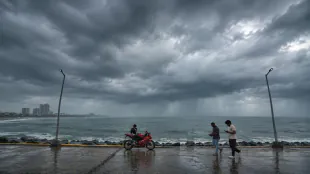
A low-pressure system is driving widespread rain and severe thunderstorms across eastern and southeastern Australia on Tuesday. This weather event follows substantial rainfall in South Australia, where Adelaide recorded its wettest winter in 22 years. Flood watches have been issued for parts of South Australia, New South Wales, and Victoria as the system moves eastward.
A low-pressure system is bringing heavy rain and potentially severe thunderstorms to parts of New South Wales, Victoria, and Queensland on Tuesday. This follows significant rainfall in South Australia on Monday, which delivered the region's heaviest August rain in 34 years.
The weather system, aided by an associated trough, is tapping into abundant atmospheric moisture to cause widespread rain and storms across southern, central, and eastern Australia during the first half of the week. On Monday, heavy rain fell over southern South Australia, while a long line of thunderstorms stretched more than 1,500 kilometers north across the Red Centre into the Northern Territory.
The Weatherzone Total Lightning Network recorded approximately 70,000 lightning pulses across South Australia, the Northern Territory, and western Queensland between midday on Monday and 6 am AEST on Tuesday. The wet and stormy weather then spread eastward into New South Wales, Victoria, and Queensland by Tuesday morning.
Multiple bouts of rain affected the Mount Lofty Ranges and Adelaide region on Monday and Tuesday morning. These areas recorded widespread 24-hour rainfall totals of 20 to 50 millimeters, with isolated falls reaching 60 to 70 millimeters. The latest round of rain has brought Adelaide’s running total for the winter season to 293.8 mm, making it the city's wettest winter in 22 years.
Rain associated with the system began spreading across parts of Victoria, New South Wales, Queensland, and the Australian Capital Territory on Monday night. By 9 am local time on Tuesday, some areas in southern inland New South Wales and the ACT had received 30 to 60 millimeters of rain. Parts of central and northeast Victoria recorded 15 to 45 millimeters. Falls were lighter in Queensland as of Tuesday morning, with 5 to 15 millimeter totals across the state’s far west and southwest.
Rain is expected to continue over parts of Victoria, New South Wales, the ACT, and Queensland on Tuesday. Thunderstorms are likely to develop over northern Victoria, western New South Wales, and southern Queensland, most probably in the afternoon and early evening. Some of these storms may become severe, posing threats of damaging winds, large hail, and heavy rain.
On Wednesday, showers will mostly contract to eastern New South Wales and southeast Queensland as the system moves offshore. Lingering atmospheric instability may cause a few more thunderstorms in central and northeast New South Wales and far southeast Queensland, although these are generally expected to be less intense and widespread than Tuesday’s storms.
Rain will also affect parts of Tasmania on Tuesday and Wednesday, with the heaviest falls in the state’s west. Snow is possible over the state’s western and central highlands as temperatures drop on Wednesday. Flood watches and warnings have been issued in parts of South Australia, New South Wales, and Victoria for this system. Severe thunderstorm warnings may also be issued on Tuesday as storm activity increases.
K.Thomson--BTB